Seminars / Lectures

New Report by IITM Scientists
General Document on Common Questions and Answers on Cloud Seeding

MoES-IITM High Resolution Global Forecast Model

REAL TIME FORECAST
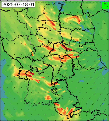
High resolution air quality forecast at 400 meter over Delhi
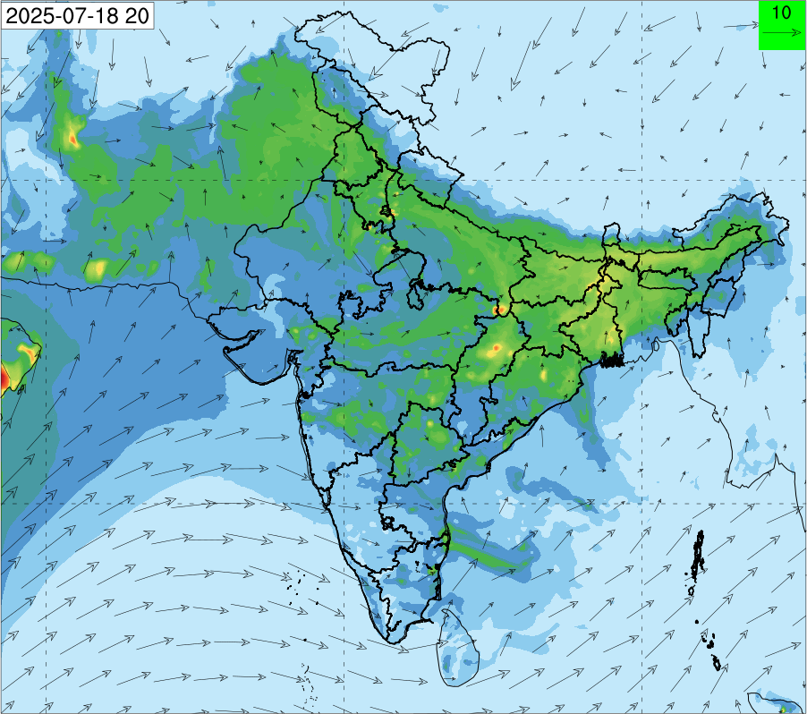
Air quality forecast at 10 km over India
IITM Publication Highlights
Climate warming increases global oceanic dimethyl sulfide emissions
 This work reduces the current large differences and biases observed in the previous outcomes of the CMIP6 models in terms of the future changes in the seawater dimethyl sulfide (DMS) concentrations and sea-air flux estimates. Machine-learning models trained with biome-resolved global observations to simulate Oceanic dimethyl sulfide (DMS) concentrations (1850 to 2100) using physico-chemical and biological predictors from eight CMIP6 models have been used for the study. The scatter in current projections is largely reduced, and globally averaged seawater DMS concentrations are predicted to decrease in the coming decades. Global DMS emissions will increase due to rising surface wind speeds and sea surface temperatures which contradicts the current AR6 assessment that the DMS flux will reduce in the future. Concurrence of increasing DMS emissions and declining anthropogenic sulfur dioxide emissions suggests an increase in the relative importance of DMS to sulfate aerosol formation and its climate cooling impact.
Joge S.D., Mansour K., Simó R., Galí M., Steiner N., Saiz-Lopez A., Mahajan A.S., Proceedings of the National Academy of Sciences, 122: e2502077122, June 2025, DOI:10.1073/pnas.2502077122, 1-9
Read MoreAssessment of the Indian Lightning Location Network (ILLN) using ground-based and satellite observations
 The Indian Lightning Location Network (ILLN), established by IITM, aims to enhance understanding of lightning characteristics, thunderstorm dynamics, nowcasting/forecasting, data assimilation, and improve mitigation strategies nationwide. Various methods have been employed to assess the network's detection efficiency, yielding reasonable detection capabilities. The detection accuracy of ILLN was thoroughly evaluated using a comprehensive approach, including ground-based observations with electric field mills (EFMs) and C-band polarimetric radar, alongside satellite data from the Global Precipitation Measurement (GPM) mission and the ISS Lightning Imaging Sensor (LIS). The findings underscore the challenges and reliability of lightning detection methods, showcasing the consistency of ILLN observations across diverse scenarios. The network's reliable detection efficiency increases its utility for various applications, serving as a valuable data source for organizations like the India Meteorological Department and national and state disaster management authorities. ILLN's widespread implementation significantly contributes to mitigating the adverse impact of lightning-induced incidents.
Biswasharma R., Domkawale M.A., Ghosh R., Gangane A., Umakanth N., Sunil Kumar, Gopalakrishnan V., Pawar S.D., DiGangi E., Deshpande S.M., Samanta D., Sharma S., Atmospheric Research, 320: 108069, July 2025, DOI:10.1016/j.atmosres.2025.108069, 1-15
Read MoreLower atmospheric profiling for climate studies pertaining to aerosols, radiation and turbulence using Unmanned Aerial System in India: Initial results
 This study focuses on using Unmanned Aerial Systems (UAS) for lower atmospheric profiling in India, specifically to study aerosols, radiation, and turbulence relevant to climate research. Initial results from the newly established Lower Atmospheric Research using Unmanned Aerial system facility (LARUS) are presented, highlighting the efficacy of the UAS in gathering in-situ measurements and identifying data gaps. It is envisaged that the UAS will evolve as a significant airborne platform for atmospheric research purposes in the coming decades. This emerging technology can be moulded as per the scientific requirement and increase its capabilities to reduce the science data gaps in climatologically important regions by sampling at a higher vertical resolution, increased frequency and duration significantly. Knowledge gained through these initial experiments, will lay a roadmap for future science missions. In the near future, it is aimed to conduct special experiments for targeted measurements during Intensive Observational field Programs (IOPs) co-located with various ground observations in India.
Padmakumari B., Kalgutkar S., Nikam M., Mukherjee S., Atmospheric Environment, 351: 121211, June 2025, DOI:10.1016/j.atmosenv.2025.121211, 1-16
Read MoreImproved storm surge prediction and extreme sea level future projections in the Indian Ocean using deep learning
 Accurate storm surge and extreme sea level (ESL) prediction is crucial for effective coastal flood monitoring and hazard management. Study reveal that future ESL changes will be predominantly driven by MSL rise, with contributions from tides and storm surges. This paper demonstrates the robust performance of the LSTM model, which outper forms existing global surge reconstructions by realistically capturing storm surges associated with tropical cyclones and extreme conditions.accounting for approximately 10%.. The analysis indicates a rapid emergence of ESL events in the Indian Ocean. By 2030–2040, equatorial islands will experience the one-in-a-hundred-year ESL (ESL100) annually, and the Arabian Sea coastline and the south subtropical regions by 2050 under a high-emission scenario. Findings underscore the urgent need to implement adaptive measures to safeguard vulnerable coastal populations.
Sreeraj P., Swapna P., Singh Manmeet, Krishnan R., Environmental Research Letters, 20: 084058, July 2025, DOI:10.1088/1748-9326/ade9e0, 1-15
Read MoreNew Publications

Reflectivity-Rain Rate Relationship for Orographic Rainfall at Mahabaleshwar Over the Indian Western Ghats
Kumar Amit., Srivastava Atul K., Chakravarty Kaustav, Srivastava M.K., Pure and Applied Geophysics, Online, June 2025, DOI:10.1007/s00024-025-03761-8, 1-13

Long-range transport of polluted Asian summer monsoon air to high latitudes during the PHILEAS campaign in the boreal summer 2023
Riese M., Hoor P., Rolf C., Kunkel D., Vogel B., Köllner F., Pöhlker M., …, Fadnavis S., … et al., Bulletin of the American Meteorological Society, Online, July 2025, DOI:10.1175/BAMS-D-24-0232.1

Improved summer monsoon rainfall extreme indices over India from CMIP6 simulations and projections
Hikare N.L., Konda G., Chowdary J.S., Gnanaseelan C., Theoretical and Applied Climatology, 156: 392, July 2025, DOI:10.1007/s00704-025-05614-9,1-12

Rainstorm characteristics using MESO-scale rain gauge NETwork (MESONET) over Mumbai
Guttula C., Sunilkumar K., Das Subrata Kumar, Urban Climate, 61: 102385, June 2025, DOI:10.1016/j.uclim.2025.102385, 1-10
IITM Events

Launch of Bharat Forecast System (BharatFS)
(26th May 2025)
India’s most advanced short- and medium-range weather prediction model Bharat Forecast System (BharatFS) was officially dedicated to the Nation was launched on 26th May 2025 at Vigyan Bhawan, New Delhi, by the hands of the Hon’ble Minister of Earth Sciences. IITM has developed this high-resolution global forecast system runs on a TCo grid at 6 km resolution, placing India among the global leaders in operational weather forecasting.

S2S AccelNet Hydrology Workshop
(16–18 June 2025)
A 3-day S2S AccelNet Workshop “Climate-informed Flood Prediction and Water Management". S2S-AccelNet Team organized this workshop in collaboration with Indian Institute of Tropical Meteorology (IITM), Pune and India Meteorological Department (IMD). The workshop aimed to address gaps in climate information use for flood prediction and water management in India, enhance understanding of S2S forecasting, provide hands-on experience with advanced tools, and promote interdisciplinary collaboration.

IAMAS/ICTM Workshop Cum Panel Discussion
(30 June 2025)
One day workshop cum panel discussion on "Monsoon Variability, Predictability, and Prediction" was held at IITM Pune in hybrid mode. The event brought together leading scientists from around the world to discuss critical issues in monsoon science. The event reflected a collective effort by the global climate science community to improve understanding and prediction of the Indian Summer Monsoon.

Swachhata Pakhwada 2025
(1-15 July 2025)
IITM observed Swachhata Pakhwada 2025 with impactful initiatives—awareness drives, a health camp, visits to a school for mentally challenged children, an old age home, and a gaushala. Activities included sanitation drives, material distribution, and a fun eco-awareness game in a municipal school, concluding with a tree plantation Program.